GIS in map publishing
The challenge
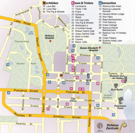
"Let's just have a quick look at the map before we set off … " A travel guide map represents a special challenge for cartographers. There must be a logical association between its content and that of the associated text. The map generalisation must result in a good level of legibility and unambiguous labelling. It is these features that characterise the maps in Michael Müller Verlag's publications and make them instantly recognisable.
At some point, it became necessary to search for a new overall solution for the production process, owing to increased technical requirements resulting from multiple data usage and the merging of several individual data sources, and the eventual abandonment of the previous system. In particular, what the company was looking for was a solution that could handle the kind of OpenStreetMap basic maps utilised by the map maker. These maps place heavy demands on the generalisation and harmonisation processes, bearing in mind that data is supplied in varying qualities.

It was a great challenge to move over to a GIS system after twenty years of freehand cartography. Even with five years experience with this new technology, we are still discovering new potential for creating increasing efficiency. FME enables us to adapt flexibly to the demand for multiple use of spatial data in our print and electronic products. Repeating workflows can be oriented towards eventual automation from the moment the data is obtained.
Michael Müller - Publisher
The Customer
For more than 30 years, the name Michael Müller Verlag has been synonymous with quality travel guides. The publisher offers an extensive range of book products, comprising several series of travel and hiking guides, numbering over 200 titles in all.
Michael Müller Verlag also shows considerable publishing and business innovation in the way it has embraced new media. For several years now, holidaymakers wishing to discover cities or enjoy hiking trips have been making increasing use of digital travel guides. The company's web site contains a number of active forums as well as innumerable useful links, making it an essential source of information for all.
The market leader in individual European travel guides has repeatedly been the recipient of prestigious awards from both the world of publishing and the tourism industry. The company's unique know-how combined with the design of its publications and, in particular, their exemplary map components, not only satisfy the needs of travellers but have also won over several jury panels.
The Solution
The ArcGIS system from Esri fulfils all the requirements of map publishing in terms of customisation, data consistency, and scalemodified display. Economic aspects have also been taken into consideration, with database linking, the use of templates for the digitisation process, and increased automation. FME is employed for pre-processing the OpenStreetMap data and for quality assurance. This ensures that geoprocessing is userfriendly, efficient, and largely automated.
Technology Used

ArcGIS

FME Desktop

OpenStreetMap
Benefits
The integration of ArcGIS as a central cartographic tool has proven to be the right step. The display can be modified without altering any basic data. Labelling can be performed with Maplex, and symbolisation makes use of representations. The exchange of data with Adobe Illustrator for graphical elements is unproblematic. All in all, despite the increase in user numbers, the implementation not only resulted in an increase in efficiency but also brought about improvements in error prevention management.
OpenStreetMap data is taking on an increasingly central role for the Michael Müller Verlag travel guide publishers. FME is employed for the purposes of managing the extensive data volume and ensuring data heterogeneity, as well as for standardising data and preparing and modifying it for the internal GIS cartographic process with ArcGIS. This enables a high level of automation and saves a great deal of time in comparison with conventional working methods.
Summary

Extensive automation of processing procedures

High degree of standardisation

Improved quality management

Optimised pre-processing of OpenStreetMap data

High usability

Major savings in both cost and time

Henning Birkenbeul

