map.apps Offline

The solution for mobile use without network connection
map.apps Offline is a product extension for map.apps, designed for mobile use in situations with unstable or no network connection. With map.apps Offline, all the essential functionalities of map.apps are available to users at any time. In addition to presentation, search, and query functions, objects can also be edited offline. An intuitive service-based process handles the synchronisation of edited data between the user device and the centralised data storage.
Highlights

Mobile use without network connection
The creation and use of custom Apps, optimized to the particular application, is very easy with map.apps. The displayed content are usually incorporated in the App as services, which necessitates the availability of an Internet connection on the user’s device.
With the offline extension, it is now possible, for the first time, to use map.apps in unstable network conditions, or where no connectivity is available at all. The outdoor use of mobile devices for certain applications is now made possible, because the application remains fully functional, independent of device capability and network coverage.
Easy Data and Maps
Synchronization All information required for the specific application is transmitted to the device to be used in advance of off-line use. Here, map.apps Offline uses directly the server-side data and service structures. Following selection of the desired spatial area, required vector data is transmitted to the device via ArcGIS feature services, and stored in the local cache. The automatic transfer of symbolization enables a similar appearance of the specialist data while in offline mode. The transfer of raster-based background maps is carried out by copying the corresponding server cache directories on the device.
Optimized functionality - both online and offline
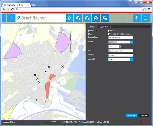
The interface of map.apps offline applications has been optimized for mobile use on devices with touch screen or pen input. The Offline / Online status is automatically recognized, and can be displayed to the user at any time. All client-side functions are available with map.apps offline, even without network connectivity. This includes the editing of objects with geometry and attribute data, including snapping functionality. New objects can be added and existing features modified or deleted. All changes can be written back to the central database upon return, or when a network connection is again available.
Numerous other features, such as locating your own position, searching specialised data, creation and use of spatial bookmarks, and the ability to save and load the application state, all support the mobile worker and contribute to an efficient off-line use of map.apps.
Feature Profile
Use of map.apps in instable or missing network connection
Synchronization of vector objects (geometries, specialist data, symbolization)
Availability of all essential display, search and query capabilities
Full editing (geometric and attribute data) including snapping functionality
Functionality to save and load application states
Memory management to display the local store and delete the locally stored objects
Automatic detection and display of online / offline status
Interface optimized for mobile use on devices with touch screen or pen input
Barry Masterson